With Gustav having just made landfall as a category two hurricane around Cocodrie, (home of some excellent fishing), I thought it would be appropriate to spend some time on the the types of assets that are in the Gulf and in southern Louisiana that can be bothered by wind and waves - and where these assets are located. With crude down close to $8 on the board this morning, clearly none of these assets were damaged.
First, there are production platforms in the Gulf of Mexico. Some of these platforms are very expensive, complicated pieces of equipment - especially those that are located in deep waters. They are all named, and there are several that you may have heard of, like Thunderhorse, Atlantis, Mars, and LaKika. These platforms run upwards of $1.0 billion to build. Here is a great map from The NEW YORK TIMES:
Those pipelines are connected to a vast array of interconnected undersea gathering systems - often times much more expensive than the platform. Violent seas have the potential to cause underwater landslides, that can damage pipelines and gathering systems.
Additionally, off the coast of Louisiana is an offshore import terminal called the LOOP (Louisiana Offshore Oil Port). The LOOP is the only port in America that can handle the very largest crude ships ULCC's (Ultra Large Crude Carriers) and VLCC's (Very Large Crude Carriers). The Hurricane came very close to LOOP and Port Fourchon, the port that serves to support the offshore facility.
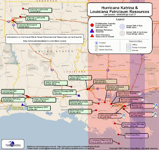
The final image is from The Oil Drum, and it is an old image of the terrestrial oil industry infrastructure that is in southern Louisiana. The path shown in red is the path of hurricane Katrina.


No comments:
Post a Comment